")
About us
- EPP
- About municipality
- Hits: 9257

As a result of the political-administrative division of 1976, the municipality of San Antonio del Sur arose, which gets its name from the popular town council, which was named after the local people.
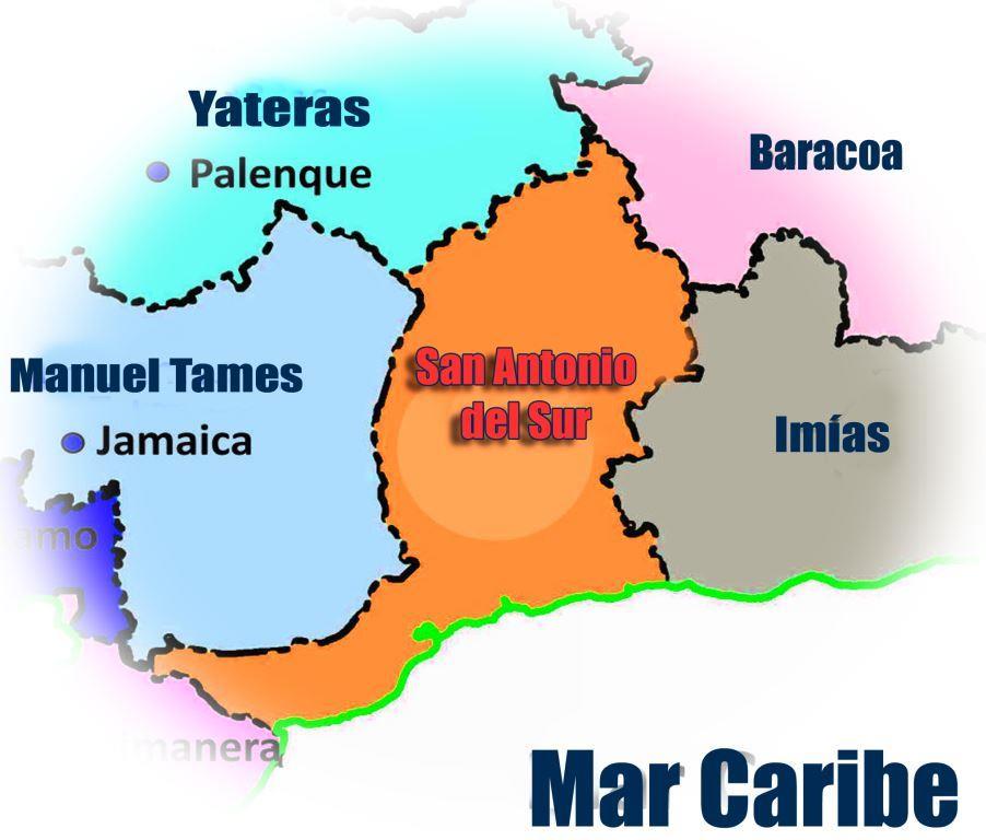
The San Antonio del Sur municipality is located in the Guantánamo province, occupying the central part and the southern coastal strip of this. Its current delimitation, with a territorial extension of 585 km2 (58494.21ha) represents 9.5% of the total surface of the province. Population of 26,886 inhabitants for a population density of 44.3 inhab / km².
It limits the North with the municipalities Baracoa and Yateras, the South with the Caribbean Sea, the East with Imías and the West with Manuel Tames. Its geographical location facilitates, through the Guantánamo - Baracoa highway, the revitalization of economic relations with the rest of the province.
Of essentially mountainous topography, all its territory belongs to the Turquino Plan. It is made up of 5 popular councils: Yateritas, San Antonio del Sur, Guaibanó, Maya and Puriales de Caujerí, as well as Viento Frío as an independent constituency. This administrative structure includes 25 concentrated human settlements that make up a system, of which only one classifies as urban (San Antonio del Sur), complemented by the dispersed population.
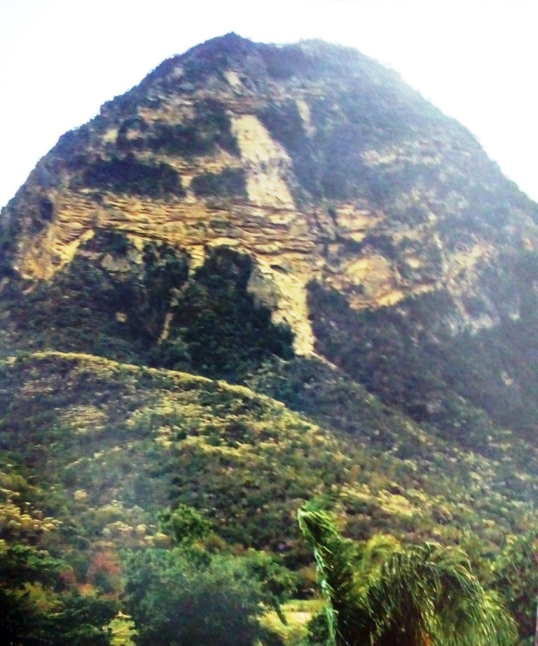
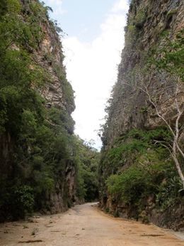
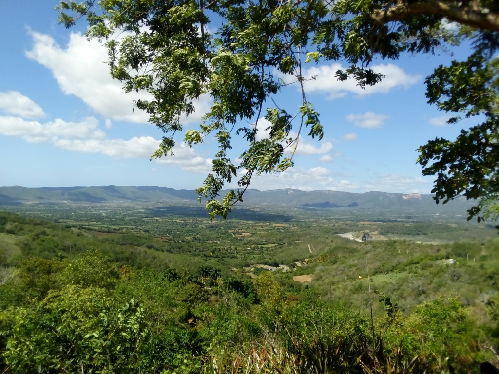
There are 4 protected areas where La Loma de Pan de Azúcar stands out, which stands majestic as guardian of the territory, is the one that José Martí said in 1895, tall among many, was also the scene of a historical event the capture of Yarey, Abra de mariana, opening between the river, preserves the testimony of having seen the apostle from the front in 1895 who, observing him, said that mountain to the right, with a gash like blood near the top, that is Doña Mariana, Terraza Marina de Baitiquirí, wonder to the visitors with the 5 levels of terraces staggered in the area known as Bate Bate, Caujerí Valley, fertile plain surrounded by mountains, baptized by the Commander-in-Chief as a Natural Productive Garden.
San Antonio del Sur is identified for being a municipality with an economic base, mainly agricultural, with productions such as coffee, cocoa, forestry, in addition to others such as various crops, livestock, fruit and forestry included in the national balance.
The municipality's agricultural production base is based on four main productive poles: Valle de Caujerí, Yateritas, Puriales de Caujerí, and San Antonio del Sur.
Most of the municipality's soils are part of fragile ecosystems such as mountainous and steeply sloping areas, with high risk of erosion, and adjacent coastal areas or cumulative plains with risk of salinization.
The climatic conditions vary of evident way towards the North where the precipitations are abundant and oscillate between 200 and 2000 mm, in the South very little between 300 and 600mm, in the center between 600 and 900 mm. The vegetation is a reflection of the climatic characteristics of the territory, since in the South there is very thorny coastal xeromorphic scrub vegetation, passing through ever thicker and more humid plant transformations up to the northernmost portion of the municipality where there is a humid tropical forest.